
开放街道地图
STDIOMCP的OpenStreetMap地图集成服务
MCP的OpenStreetMap地图集成服务
This package provides OpenStreetMap integration for MCP, allowing users to query and visualize map data through an MCP interface.
This is my claude_desktop_config.json:
{
  "mcpServers": {
    "OSM PostgreSQL Server": {
      "command": "/Users/wiseman/.local/bin/uv",
      "args": [
        "run",
        "--env-file",
        ".env",
        "--with",
        "mcp[cli]",
        "--with",
        "psycopg2",
        "--with-editable",
        "/Users/wiseman/src/mcp-osm",
        "--directory",
        "/Users/wiseman/src/mcp-osm",
        "mcp",
        "run",
        "mcp.py"
      ]
    }
  }
}
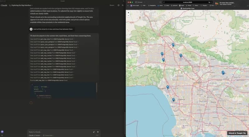
When the MCP server starts it also starts a web server at http://localhost:8889/ that has the map interface.
The following environment variables can be used to configure the MCP:
FLASK_HOST - Host for the Flask server (default: 127.0.0.1)FLASK_PORT - Port for the Flask server (default: 8889)PGHOST - PostgreSQL host (default: localhost)PGPORT - PostgreSQL port (default: 5432)PGDB - PostgreSQL database name (default: osm)PGUSER - PostgreSQL username (default: postgres)PGPASSWORD - PostgreSQL password (default: postgres)The following MCP tools are available:
get_map_view - Get the current map viewset_map_view - Set the map view to specific coordinates or boundsset_map_title - Set the title displayed at the bottom right of the mapadd_map_marker - Add a marker at specific coordinatesadd_map_line - Add a line defined by a set of coordinatesadd_map_polygon - Add a polygon defined by a set of coordinatesquery_osm_postgres - Execute a SQL query against the OpenStreetMap database