
OpenStreetMap
STDIOOpenStreetMap integration for MCP with map visualization and querying capabilities
OpenStreetMap integration for MCP with map visualization and querying capabilities
This package provides OpenStreetMap integration for MCP, allowing users to query and visualize map data through an MCP interface.
This is my claude_desktop_config.json:
{
  "mcpServers": {
    "OSM PostgreSQL Server": {
      "command": "/Users/wiseman/.local/bin/uv",
      "args": [
        "run",
        "--env-file",
        ".env",
        "--with",
        "mcp[cli]",
        "--with",
        "psycopg2",
        "--with-editable",
        "/Users/wiseman/src/mcp-osm",
        "--directory",
        "/Users/wiseman/src/mcp-osm",
        "mcp",
        "run",
        "mcp.py"
      ]
    }
  }
}
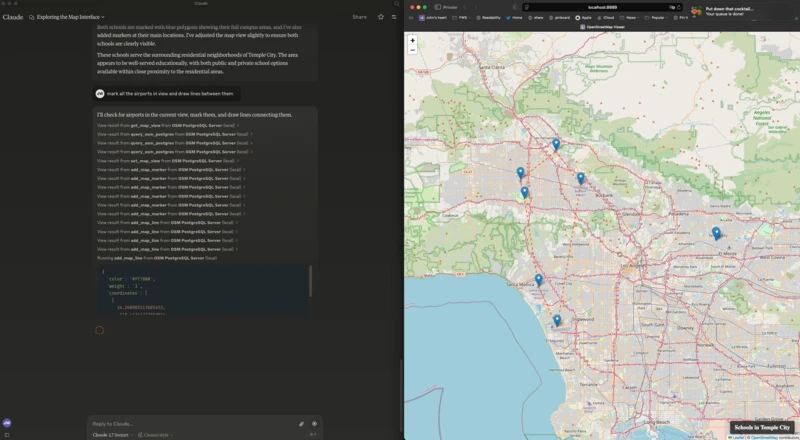
When the MCP server starts it also starts a web server at http://localhost:8889/ that has the map interface.
The following environment variables can be used to configure the MCP:
FLASK_HOST - Host for the Flask server (default: 127.0.0.1)FLASK_PORT - Port for the Flask server (default: 8889)PGHOST - PostgreSQL host (default: localhost)PGPORT - PostgreSQL port (default: 5432)PGDB - PostgreSQL database name (default: osm)PGUSER - PostgreSQL username (default: postgres)PGPASSWORD - PostgreSQL password (default: postgres)The following MCP tools are available:
get_map_view - Get the current map viewset_map_view - Set the map view to specific coordinates or boundsset_map_title - Set the title displayed at the bottom right of the mapadd_map_marker - Add a marker at specific coordinatesadd_map_line - Add a line defined by a set of coordinatesadd_map_polygon - Add a polygon defined by a set of coordinatesquery_osm_postgres - Execute a SQL query against the OpenStreetMap database